- 2:00 h
- 6.44 km
- 160 m
- 160 m
- 339 m
- 506 m
- 167 m
- Start: Parking lot / station Druseltal
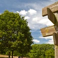
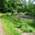
The circular trail, rated difficulty level 3, invites you to take a walk to the Bismarck Tower and Fritz Catta Corner. The 6.5-kilometer trail is half uphill and can be completed in 100 minutes. In connection with the Quellenweg 1, it opens up the Druseltal from the other side and brings you back to your starting point.
Good to know
Pavements
Gravel
Trail
Best to visit
suitable
Depends on weather
Directions
Please follow the marker K3 in the indicated walking direction. Zeche-Marie-Weg, Bismarck Tower, Fitz-Catta-Eck and back.
Tour information
Loop Road
Equipment
Standard hiking equipment required.
Directions & Parking facilities
Coming from the city, take the Druseltalstraße. The parking lot is located at the streetcar terminus.
Take streetcar line 4 from the city center to the final stop Druseltal.
Author
Kassel Marketing GmbH
Organization
License (master data)
Kassel Marketing GmbH

Author´s Tip / Recommendation of the author
The view from the Bismarck Tower is overwhelming.
Social Media
Nearby