Premiumweg P1 Hoher Meißner

- 5:00 h
- 13.00 km
- 509 m
- 509 m
- 542 m
- 748 m
- 206 m
- Start: several hiking parking spaces: Schalbenthal, Frau-Holle-Teich, cattle house, mountain inn
- Destination: = starting point
Here you get detailed information about all tours incl. Route download, map material and offline additional information in our Geo-Naturpark-App.
Good to know
Pavements
Unknown (100%)
Best to visit
suitable
Depends on weather
Directions
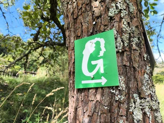
signposted in both directions. GPS track with additional information in the free Geo-Naturpark-App
Tour information
Barrier-Free
Cultural Interesting
Loop Road
Nature Highlight
More information
Deutsches Wandersiegel Premium Wanderwege
Deutsches Wandersiegel Premium Wanderweg
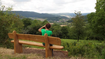
Premium hiking trails are stretches and circular hiking trails that are excellently marked and have a particularly high experience value. A balanced, beautiful hiking experience is guaranteed on premium hiking trails. Pleasant road surfaces and paths, a selected dramaturgy with great views, beautiful forest pictures, water bodies, rock structures, well-kept resting and resting places, cultural-historical gems and many other variety make the hike on premium hiking trails a special pleasure.
Deutsches Wandersiegel Premium Wanderweg
Premium hiking trails are stretches and circular hiking trails that are excellently marked and have a particularly high experience value. A balanced, beautiful hiking experience is guaranteed on premium hiking trails. Pleasant road surfaces and paths, a selected dramaturgy with great views, beautiful forest pictures, water bodies, rock structures, well-kept resting and resting places, cultural-historical gems and many other variety make the hike on premium hiking trails a special pleasure.
Author
Chantal Witzel
Organization
License (master data)
Chantal Witzel

Safety guidelines
Wichtige Hinweise zu aktuellen Einschränkungen an unseren Wanderwegen (naturparkfrauholle.land)
Nearby
Download GPX file