Bartenwetzerpfad U


- 25:30 h
- 113.00 km
- 2,320 m
- 2,320 m
- 155 m
- 516 m
- 361 m
- Start: Church, 34212 Melsungen-Adelshausen
- Destination: Church, 34212 Melsungen-Adelshausen
The Bartenwetzer Trail - marked with the white U on a black background - conveys the beauties around Melsungen in a magnificent way:
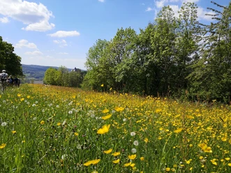
In addition to Spangenberg Castle, the Heiligenburg, the Karthause, the fortified church of Dagobertshausen, it touches many small villages, leads through magnificent beech and mixed forests over scenic heights with views of the entire Kurhessische Bergland (Meissner, Söhre, Kellerwald, Habichtswald, Alheimer, etc.).
It is about 115 kilometers long and includes 6 daily stages of about 20 kilometers:
Stage1: "Up and down to the Metzebacher Höhe".
From Melsungen-Adelshausen to Metzebacher Höhe
Length: approx. 19 kilometers
More information: Bartenwetzerpfad U - Etappe 1 (melsunger-land.de)
Stage2: "Where the French once roamed".
From the Metzebacher Höhe to Vockerode-Dinkelberg
Length: approx. 18 kilometers
More information: Bartenwetzerpfad U - Etappe 2 (melsunger-land.de)
Stage 3: "Over heath, castle and Finstere Höhe".
From Vockerode-Dinkelberg via Spangenberg to Günsterode
Length: approx. 16 kilometers
More information: Bartenwetzerpfad U - Etappe 3 (melsunger-land.de)
Stage 4: "Over Wildbahn and Green Lake
From Günsterode via Kehrenbach and Eiterhagen to Körle
Length: approx. 19 kilometers
More information: Bartenwetzerpfad U - Etappe 4 (melsunger-land.de)
Stage 5: "Always along the rivers".
From Körle Büchenwerra and the castle ruin Heiligenberg to Beuern
Length: approx. 19 kilometers
More information: Bartenwetzerpfad U - Etappe 5 (melsunger-land.de)
Stage 6: "Closing the circle".
From Beuern via Dagobertshausen to Melsungen-Adelshausen
Length: approx. 20 kilometers
More information: Bartenwetzerpfad U - Etappe 6 (melsunger-land.de)
The Bartenwetzer Trail was developed and marked in 2002 by the hiking group of the Heimat- und Verkehrsverein Adelshausen.
Good to know
Pavements
Best to visit
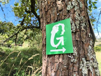
Route markings
 Path marking
 Tour information
Barrier-Free
Cultural Interesting
Loop Road
Documents
Author
Tourismusgesellschaft Melsunger Land mbH
Organization
License (master data)
Tourismusgesellschaft Melsunger Land mbH

Nearby

Download GPX file